Copyrights @ Journal 2014 - Designed By Templateism - SEO Plugin by MyBloggerLab

Sunday, 10 January 2010

First hike of 2010 - Prabalgad and Kalavantin pinnacle


I might need to rename this blog since over the past two years I have done probably more winter hikes than monsoon ones. 2009 was particularly dismal due to my work schedule and erratic rains. However 2009’s late rains have meant that all winter hikes are turning out to be great.

The decision to go to Prabalgad was very last-minute. This decision was inspired by my friend Lobhus’ earlier solo hike to the place which in turn was inspired by my brother’s solo sojourn to another place. Since neither I nor my friend Shripati would ever go alone for a hike, just the two of us decided to do the hike.

Prabalgad is a great trek in the rains but most often I have been lost in the forests. So as a winter hike option it seemed right and we could study the directions properly this time. We set out to Panvel by train and then took a bus to Thakurwadi village which goes via the old Bombay-Pune road. (The first two buses leave Panvel at 5.20 and 7.00)

We alighted at Thakurwadi and had to move past various new constructions that have come out in the last few years including a Zola mountain spa and some aesthetically unpleasing houses built by Dharap associates (if you are planning to buy a place here, you should invest your money elsewhere; though the owners’ pads are better landscaped….) Even Salman Khan has a house somewhere around the area!

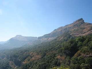
One has to walk on a private tarred road belonging to Dharap before the climb begins. The well-marked path zig-zags towards the northern end of the Prabal plateau or machi. One the top is the Prabal machi village which though is in nice surroundings, is quite dirty with plastic garbage. On the left is the Kalavantin pinnacle and next to it is the wide expanse of Prabal fort. About half an hour or so from the village one reaches the base of the pinnacle from where wonderfully rock cut steps climb steeply taking one to the top which is a final mass of rocks. The last rock climb is easy for experienced trekkers and the summit has a single flag and great views.

We started our hike around 8 in the morning and had reached the summit around 9:30. We made our way back to the village to tackle Prabal. The Kalavantin pinnacle sees more hikers nowadays; its thrills are easy and fast, kind of like trekking fast-food! The villagers seem to pronounce it more like Harish Kapadia’s book says- Kelveteen; I am not sure which nomenclature is right. Prabalgad on the other receives less visitors but its charms have to be hard-earned. A walk across the machi through bushy forest takes us to the centre of the massif from where a steep path arises. We lost our way once but had a nice walk on the machi, amidst flowering greenery. We had to retrace our path to find a bifurcation (near a large tree) from where thankfully arrows were painted on rocks. A sturdy climb (quite hot around twelve o’clock) took us into the fort. The top is a large plateau comparable to Matheran and is thickly forested. One can ramble around for hours; we went following the arrows to the northern end, where there is a water tank. One can see views of Matheran range and also sight some of the bastions of the fort. At the extreme end a fabulous view of the Kalavantin pinnacle is a must-do.

We started descending around two and had to hurry down to reach by four for a bus back to Panvel. The great thing about Prabal is that it’s so easy to reach from Bombay and yet the seclusion and wilderness at the top is so great. We did not see a single soul at the top of the fort but we did catch sight of a few birds, a couple of grey langurs and a lizard or two. Throughout the hike there were lots of flowers and blooms so that there were bees buzzing by and butterflies flitting about. Truly a great way to spend an idyllic winter day!


As usual photos are on Picasa at: http://picasaweb.google.co.in/upsidedownv/Prabal2010?feat=directlink


Monday, 14 December 2009

, ,

Harischandragad Reloaded: Nalichi Vaat Trek

I have a photo of myself on Harischandragad, sitting near Konkan Kada among flowers. Its an old photo from one of my earliest hikes and that particular hike was a benchmark for all other hikes in terms of personal enjoyment and satisfaction. Since it had been more than ten years since I last visited Harischandragad I had been planning to go back for quite some time. So when the opportunity came I jumped along to go with a trekking group in order to tackle the difficult ‘Nalichi vaat’ route.

It was the first time that I was going with a trekking group; my uncle Anu mama and cousin Ameya joined me and we met the group Trekmates at Kalyan station late on Friday night. We made our way by bus to Tokavde and from there to Belpada (now Walivare) village which is at the base of the fort from the Konkan side. We were a group of about thirty and we camped for the night in the village. Next morning after a cup of tea and a round of introductions we started off.


We started towards Konkan Kada at around eight o’clock. Needless to say, the views were fantastic. The walk quickly became a climb and soon we were in the ‘nali’ or the waterfall which was completely dry by this time of the year. The climb became steep but the group was full of able-bodied trekkers and we had climbed a fair amount by eleven in the morning. It was time to eat, drink and recharge.

After we started to climb the incline became steep. Generally the route takes around eight hours to climb and soon we knew why! (Everybody was feeling good about our initial speed!) As one climbs higher, huge rock walls appear and the ascent gets steeper. Luckily we reached this stage at the right time and we were spared from direct sunlight as the tree cover was zero. As one climbs higher rock patches need to be negotiated and the rock here is very unstable and loose. The good guys at Trekmates were prepared and helped everyone patiently.

Mama, after a serious cramp scare, was back in action. Ameya, as usual expertly climbed up the rock patches. Myself, I needed to use the rope at a couple of patches. We were all a bit discomforted by our bulky bags but managed to climb without any difficulty. However the group’s speed gets slowed down by rock climbing. About ten or so of us however moved ahead and finished the nali part only to find some more climbing was to be done, some of it on loose soil with some rock patches (easier ones) again thrown in for good measure.

Once on top of Harischandragad, the advance party rested, gorging on snacks (Chivda! Bakerwadi! Biscuits!) The views were fantastic but clarity was not good due to wintry haze. We rested for a while but getting restless after some time we decided to move on. There was one more climb after which we got on the top near Konkan Kada. The kada, of course is the highlight of the fort and needs to be experienced from the edge - words can’t do enough justice!

The remaining group took quite some time to reach us and we had ample time to take photos and enjoy the sunset. The weather was great all the time and this year’s late monsoon ensured that there was enough greenery around. Overall the trek was tiring; the climb is steep and long, especially with heavy bags. It was past sunset when the whole group arrived and the leaders decided to gather some wood for a campfire. From Konkan kada, Harischandreshwar temple and the caves are about half-an-hour away and we trudged exhausted in the dark, our hands full with branches and twigs. Finally we reached near the temple and caves and sat down to make a campfire. Then on songs were sung till dinner arrived.

When I visited the fort about ten years ago, it was less crowded with visitors; since then I had heard stories of littering and noise. Though it was not as bad as I had reckoned, there were enough trekkers around (a few of them behaving as if they missed a disco) and villagers had geared up to serve them (our dinner came from one enterprising villager up on the fort). The caves we stayed in were also fairly clean and rodent-free which might have do something with the villagers again…..

The whole day had been tiring and the earlier plan of getting up early for sightseeing never did materialize. We slept at eleven and got up at seven, fairly refreshed. Seeing that our group had fairly missed few of their deadlines, our trio decided to leave immediately and we were joined by three others on our way down. Me and my trekking companions enjoy our independent hikes; since we are few in number and like the peace and solitude, our route back was enjoyable. The usual route to the fort involves crossing the huge plateau. Even after several years the route is still as beautiful as it was, crossing flower strewn meadows and verdant forests.

We took about three hours to descend; after crossing the plateau we descended to theTolar Khind pass. Along the way we passed a couple of villages who now sit selling tea or nimboo-pani to trekkers (how they are spoiling us!) It was a pleasant surprise to have excellent buttermilk on the way down! Down at around twelve at Khireshwar village (the traditional base for a hike up the fort) we had some batata-poha and waited for a jeep to take us back.

The journey back home was uneventful as usual. As we took a jeep that cruised past the dammed waters around Khireshwar, we took a last look at Harischandragad, discussing plans in future when we will be back. After all there are still a few routes up this formidable fort that are worth exploring.


More photos at the following link.

Saturday, 26 July 2008

Two for two - Shivneri and Hadsar

We make ambitious plans. On any given hike, everyone makes grand plans to climb two, maybe three mountains or take a longer, harder route. There are also enthusiastic participants before any given hike actually occurs; people who promise to come and back out at the last minute. So this weekend, there were only two of us (myself & Lobhus) left with some ambitious plans to do two or say three forts on a single day. We were really desperate to go because we hadn't gone as yet on a monsoon hike and though it must have been the dryest July for decades, we decided take a chance on rain.

We decided to go to Junnar since we thought once we are on a higher altitude, rain or no rain, it would still be pleasant. We caught an 11 o’clock bus from Bombay Central depot, which though labelled as an express, halted at every other place, right up till five in the morning.

First on our agenda was Shivneri, which we could just about see in the dark sky. We started on the tar road behind the bus stop which goes to the fort. However we got bored of walking on the road and decided to take a short cut. A short wall has been built around the fort by the locals and there is a breach in the wall from where we entered and started on a payvaat. It took us first to a cave which was a dead end, then we went back and took another direction but eventually we had to jump over the aforementioned wall and took to the tar road again.

Fortunately we had skipped much of the tar road and soon we were at the steps that take one into the fort complex. Unlike most forts visited, Shivneri is well maintained with cemented steps, tended gardens and reconstructed gates. On the top there are several ruins to see, most important of which is the birth place of Shivaji Maharaj. It was about seven in the morning and the fort was very quiet and peaceful.

To return, we decided to hunt for the alternative route which a local had told us about. This starts from a monument just before the birthplace monument and goes on the side facing Junnar town, past a really dirty tank (it stank!). The route goes through the woods and then descends downwards over the cliff face. Metal rods have been inserted for support over rock cut leg holds. It’s definitely a route for trekkers and in pouring rain, might be a bit tricky. The route descends down into the forest and reaches the newly built boundary wall at the bottom, over which you need to jump to reach the road to Junnar. This way saves you from walking most of the tar road. Looking back, it was almost impossible to figure the route among the cliff wall.

Back at the bus-stop we had just missed the 8:20 bus to Hadsar village and had to wait nearly for an hour for the next one to arrive. Any bus to Rajur-1 or Nimgiri goes via Hadsar village and the journey is about 20 minutes or so. From Hadsar village, one has to walk on the road towards a well from where the route climbs up to a plateau. From the plateau the path moves towards the left and one has to go around the mountain to reach the rock cut steps to the fort.


There is not much left on Hadsar fort but the entrance is impressive. It is squeezed between two walls of the mountain and a long series of steps takes one through a couple of darwajas till one reaches the grassy summit. The fort is divided into two unequal halves and the larger one contains water tanks, a small temple and a pond, where we decided to take a dip. Later we realized that the villagers took the buffaloes into this pond, but then it was getting a bit hot and the water was cool!

We went up to the highest point which is behind the temple from where one can see the entire fort. Adjoining is a steep ridge that takes one to Hatkeshwar plateau (which we had planned to do, but looked like a really long hike). We could also see one of Nimgiri forts. Since it was a hazy cloudy day, we could not see far, but we could recognize Shivneri, Jivdhan and Chavand forts among the shadowy shapes on the horizon!

After the dip, we had theplas for lunch and made our way back to Hadsar village where we had again missed our bus but jeeps come from time to time. In a stroke of luck we got an empty one – a pleasant contrast from the usual cramming that happens in these rides! We returned to Junnar to wait for a long bus ride back home. There was hardly any rain worth mentioning but on our way back it rained not once, but twice. Oh, the weather gods can be cruel!


More photos at: http://picasaweb.google.co.uk/upsidedownv/2008junnar

Saturday, 19 July 2008

Night Hike to Nakhind

I had to post this account months ago, but some how it just did not happen on time…..

I have never been a fan of night trekking but I believe in trying new things. So I agreed upon a night trek in May hoping that a night on any hill would be cooler than one in sweltering Mumbai. Since we were totally against walking in the sun, our options were limited as the hike had to be nearby and not too long. So we settled on to Peb or Nakhind or both (we are always ambitious in our intentions!)

There were only three of us on the hike and we took the last local to Karjat and alighted at Neral station, which was expectedly deserted. Now though I have been to this hike many times, we always make some common mistakes. Predictably we had trouble searching the way in the dark and after many detours and dogs howling about in the night, we found ourselves on the right road.

It was a pleasant night with an almost full moon (one day before pornima). There was a slight breeze but in no time we were all sweating with the climb. We reached the first TV tower and then the second and we knew we were on the right way. However as we started moving towards the col between Peb and Nakhind, we lost our way and we took some wrong turns. After almost an hour of mad exploration and discussions, we turned back and fortunately on our way back we got hold of the right path.

I found the night hike experience very surreal. It’s deadly quite and a bit eerie, everything is dipped in darkness and there’s only your torch to guide you. It does bring memories of….well, those children in the dark getting caught by leopards or those horror camping movies!

We made it up to the point between Peb fort and Nakhind and rested a bit, deciding where to go. We were drenched in sweat by then and I had never sweated so much on any trek. We decided to go to Nakhind and then made up on the steep incline to the right. The narrow ridge walk soon became forested and the eerie impression strengthened. We reached the high point but decided to go further. As there was nothing to see we decided to turn back after 30 min of more walking and came back to some rocks where we watched the sun rise. The view was nice with Prabal, Chanderi and Peb forts around us. During this we didn’t even realize that we dozed off and soon we were on our way back.

Walking down was quick but we should have been quicker. My shoe was biting me and soon by seven the sun was beating down upon us. By eight we were down and almost roasted by the sun but still alive to catch the 8:30 train which was late. We entered the platform and the train door just appeared before us and surprising we had seats. No waiting time for the train, just made this experience even nicer!

Monday, 21 January 2008

Ratangad: A Winter Hike

Ratangad by its very name (jewel among forts) attracts hikers and rightly so as it offers shelter, water, ruins and some of the finest views. I’ve made the trek in monsoon when the fort is surrounded by fog and nothing is visible. So to enjoy the fort for all it offers, I decided to go in winter.


The most used route to reach the fort is via Ratanwadi village. If you live in Bombay this means a long route to Igatpuri, then to Shendi (Bhandardhara Dam) and then a boat to Ratanwadi. Being late for booking train tickets (as usual), we took the first bus to Nasik that would drop us to Igatpuri. Unfortunately we got stuck in the mother of all jams and after four hours of being stuck (we got by with playing cards), we got down at Asangaon, took a train to Kasara, then a bad jeep ride to Ghoti and by rickshaw to Shendi and after an hour’s wait, the boat to Ratanwadi. To save time and money, I would suggest the first train to Kasara (if not a late night bus to Igatpuri) and then a bus to Rajur which would drop you at Shendi.

We spent the night at Ratanwadi as we reached there at six in the evening. There is a beautiful temple (Amruteshwar) and an ancient tank in the village. One can stay in a hall besides the temple and villagers are quite helpful. You will have every second fellow asking to be your guide! Post-dinner we went for a night walk without torches, as the moon was unusually bright and with a tripod we were shot some snaps.

We struggled to wake up at six; it was dark and freezing cold, possibly 5 degrees. We had asked one of the villagers to be our guide and when he did not show up by seven we were off. The route to the fort is forested but quite easy and distinct. At one point, it bifurcates to the route going further to Kathra and thereafter to Harischandragad (a circuit I want to do at least once!) Our guide did join us just as we started hiking and kept a good pace for us to follow.

We made it to the top in a couple of hours; there are two steel ladders just near the entrance to negotiate a rock face. After biscuits and kachoris, we went to the top where one gets excellent views of Ajoba. The highest point of the fort is the Nedhe – a hole in the rock where one gets fantastic views – as far as Jivdhan and Dhakoba. We planned to go down by the Trimbak Darwaja on the other side of the fort, which meant traversing the entire fort. The darwaja opens up into the ground and in monsoon would be real adventure. The huge steps descend steeply between huge rock walls, then the narrow route passes under a rock wall towards the Khunta Pinnacle. On one hand you can see the drop into Konkan, with another pinnacle called Baan at half level. On the other side you see the Kalsubai range up to Kulang. After going around the Kuntha pinnacle, we descended down and had a long walk to Samrad village.

Our plan was to do down Karoli Ghat from Samrad. We had a lunch break of sandwiches, while our guide gave us some delicious thecha with rice bhakris. From Samrad we walked further towards Ghatgar village where another dam has been built. This route is largely on a pucca road and luckily we got a rick to cut it short. Dropping us near an abandoned school (now submerged by the lake behind the dam) we went to the edge of the ghats where our guide left us.

We had realized by now this was not Karoli Ghat but as we did not want to be late we were fine with it. This ghat called Devicha Ghat or Chondacha Ghat, has man-made steps and because of the new dams that are below and above the ghat, is used by workers. It is an easy route that takes one to a proper road (not for public use and part of a hydroelectric project). If you are lucky (as we were!), you can get a lift till Chonda Colony. From here we quickly took jeeps to Dolkhamb, then to Asangaon/Shahpur and on to a local train and were home at six. It was a twelve hour journey right from the time we got up to the time we reached home. Fast but cool!